A practical and easily accessible solution for implementing site-specific fertilisation, which will be part of the European Agricultural Data Space and therefore create added value for the agricultural sector.
TerraZo, developed by Josephinum Research, is a web application designed to facilitate site-specific fertilization for farmers without requiring high acquisition costs for new equipment or expensive software. Based on Sentinel-2 satellite data and field trials, vegetation indices are calculated, and fertilizer recommendations for each subarea are generated using models. The resulting application maps can be exported to compatible tractor terminals or used via smartphone / tablet. Variable and site-specific N-fertilization leads to input savings, improved plant nutrition and a balanced N-budget. The platform integrates both agronomic knowledge and technical automation while allowing for user customization. Broad deployment supports direct knowledge transfer into practice.
Introduction
Site-specific fertilization has become a cornerstone of sustainable agricultural practices. However, the high costs associated with the technology and software required to implement such precision methods have often hindered widespread adoption among small and medium-scale farmers. TerraZo was developed to bridge this gap by offering a cost-effective, intuitive web-based solution for generating fertilization maps using freely available Sentinel-2 satellite data and field trial results.
Materials and methods
TerraZo processes multispectral satellite imagery (Sentinel-2) to calculate vegetation indices such as NDVI. The web interface allows users to define management zones automatically and assign fertilizer amounts based on model suggestions. The output maps can be exported in standard formats compatible with most modern agricultural terminals or used via mobile devices.
Results
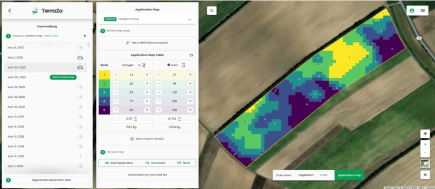
Figure 1: Example of a TerraZo-generated application map for nitrogen fertilization
Field trials with TerraZo demonstrated that variable rate fertilization maps led to more uniform plant growth and measurable input savings of up to 15%. Additional data from winter wheat trials across four representative Austrian regions confirmed nitrogen savings between 4.7% and 17.2%, with an average yield increase of 280 kg/ha and gross margin improvements up to 18%. Moreover, nitrogen balances shifted significantly toward sustainability. Such optimization not only supports economic decisions but also aligns with environmental targets.
Conclusion
As an application within CEADS, TerraZo demonstrates how the European Agricultural Data Space can create direct and tangible value for farmers, technology providers, and other agri-food stakeholders. CEADS provides the trusted European framework for secure, transparent, and interoperable data sharing by bringing together data, infrastructures, governance, and business models across the sector. Within Use Case 5, “Enhancing Machinery Data Sharing Across Europe”, TerraZo enriches this vision with a concrete, farmer-oriented application: fertiliser maps can be automatically transferred to agricultural machinery without the need for manual input. This combination shows the strength of CEADS in practice, turning trusted data sharing into better decision-making, more efficient input use, improved sustainability, and easier access to precision agriculture across Europe.